Redesigning Deltas
Rotterdam Region, The Netherlands
Location | Rotterdam Region, The Netherlands
Year | 2022
Client | Resedigning Deltas (Interdisciplinary Research Programme at TU Delft)
Collaboration | LOLA Landscape Architects, Nanco Dolman
For the city of Rotterdam, we proposed a protective strategy in which the city can safely continue to thrive as its own water supply catchment based on a closed freshwater cycle, and for the port, we developed a coping strategy based on a spatial, functional, and infrastructural transition.
The predicted sea level rise will present a multitude of challenges in the coming decades towards 2100. First, we must face spatial challenges like salt intrusion, fragmented nature, sedimentation, subsidence, serious floods, and droughts. Then we have the functional challenges, in which we are moving towards a post-carbon economy. To achieve this, a serious change of the existing industry is needed, and we need more, better, and more diversified housing and working areas. Finally, we face infrastructural challenges are that transport routes must be rethought and new clean traffic modes are needed.
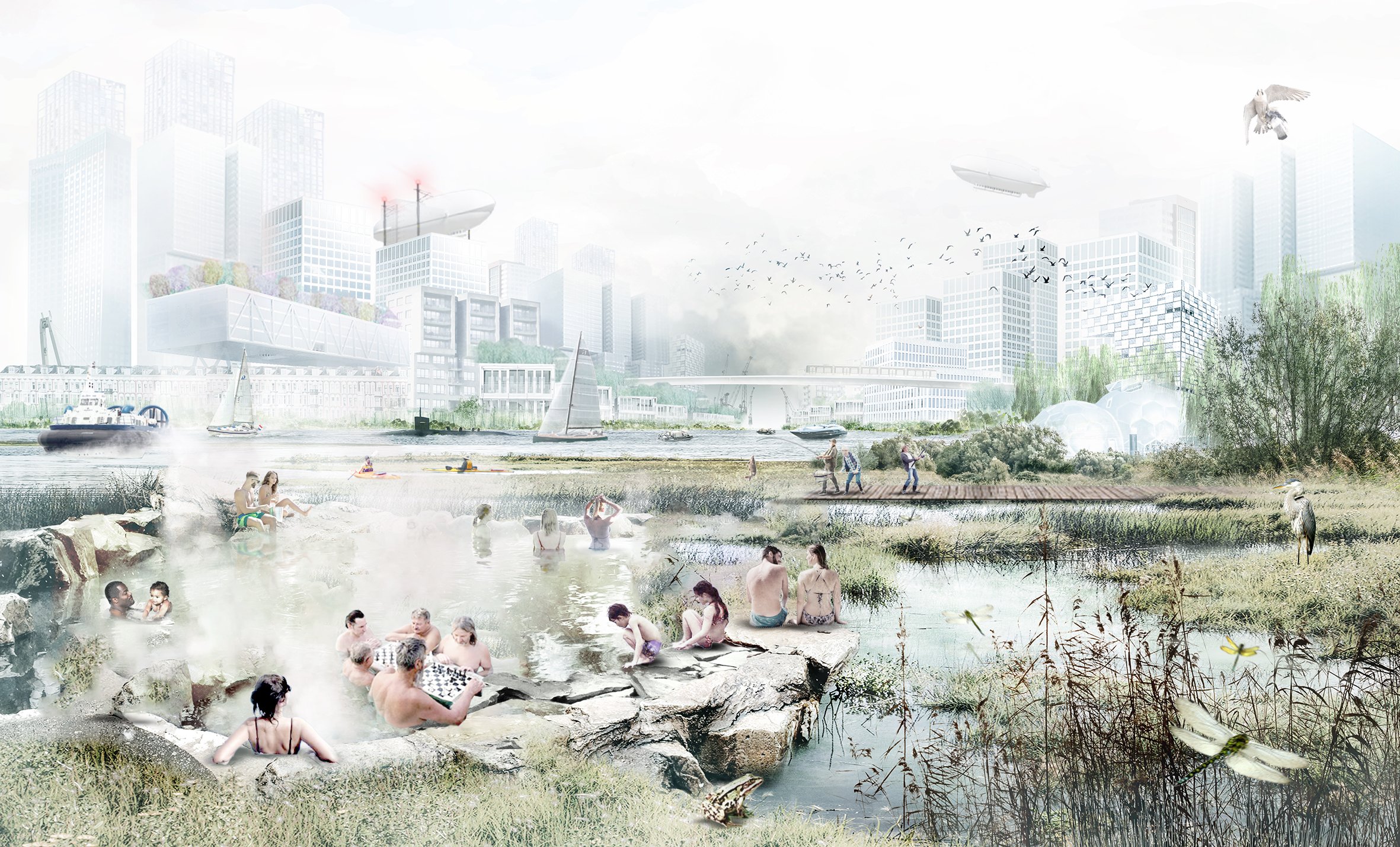
Impression of live on the Meuse and the city could look like in 2100
For the city of Rotterdam, we proposed a protective strategy in which the city can safely continue to thrive as its own water supply catchment based on a closed freshwater cycle, and for the port, we developed a coping strategy based on a spatial, functional, and infrastructural transition. The aim is to restore the water balance between the urban areas and its environment. Thinking in terms of optimal use of space and multifunctional water and 'livable city' solutions, for example, offers the concept of 'the city as a sponge': the 'collection, storage and use of water', in order to relate all water and climate challenges. The city as a sponge contributes to the resilience of the landscape in which it lies, including quality of the living environment and biodiversity.

Proposal Rotterdam region water safety and climate adaptation strategy 2100
For our proposal, we refer to the base layers that are already there, that show differences in height, landscape type, geology, and refined secondary dike structures. In our vision map, we propose different flood safety strategies for the port area and for the city of Rotterdam. The port gets a totally open shipping connection with the sea, which moves further south towards the Haringvliet and the river for transportation towards the hinterland. This creates a very large estuary and a self-sustaining port island that can move more and further into the sea. The city gets a delta dike protection and becomes a self-sufficient and circular freshwater sponge city with the river New Meuse as its central water body closed off by two double locks.
Rotterdam Sponge Watercity
For the city of Rotterdam and the entire northern part of it, we propose to shorten the dike line with a serious delta dike, that creates a highwater protection from the coast towards the Utrechtse Heuvelrug. This means closing dike ring 14, which includes the entire Randstad area and its elaborate freshwater system. We also propose to include the center of the New Meuse river and the island of IJsselmonde to create a freshwater core within the city its water system. This allows the city also to further grow and to use the potential of this central water body. Due to the closure, more housing is possible in “former” port areas outside the dykes, such as canals and houseboats. We close this part of the New Meuse off for commercial shipping, that is going towards the hinterland, this shipping moves more south. And we make the polders around the city wetter, to be able to cope with floods and droughts much better.

Section of the city of Rotterdam – Existing situation
In the first schematic section, we show the existing situation of the old Meuse river and its dikes in the south, and the New Meuse in the center (which we want to close off where it is more urbanized). Also, we see the latest highway extension (A13) next to the airport on the left side of the section, which borders the polder of Midden-Delfland. In between, you see the city its differentiated water system, and ground levels.

Section of the city of Rotterdam – Extreme climate scenario (IPCC), 3m sea level rise

Section of the city of Rotterdam – Proposal, isolating the New Meuse from the tide and connecting to inner city waters
Three-meter sea level rise will mean daily tidal floodings of all the outer dike areas in the city. And a storm tide would cause a massive flood that would need a substantial increase in dike heights and widths everywhere. We choose to do this only in the south, on the right side of the section, where there is more space, and which offers the opportunity to turn the New Meuse into a central freshwater body. This gives us three main benefits, next to a durable storm flood protection. One is the possibility to develop and densify in relation to the water, two is to make a generous public space in which people can recreate and also creates more natural banks and islands, and three Is that we introduce an intelligent water machine that can fight the huge droughts and extreme rain floods. Where the port moves west, quite a huge potential for densification appears, the water can be used more intensely because of the boat traffic on the water is gone for a large part. Also, we can soften waterfronts and make them more accessible and greener and an intelligent fresh urban water system supports the city as a sponge.
As a sponge city Rotterdam needs to absorb 70 mm on all paved surfaces within two hours (green polder roofs, wadis, rain gardens, water squares, soil improvement, storage under roads, etc.). Additionally, the collected rainwater can be buffered locally in the city, such as the so-called 'urban water buffers'. Collecting rainwater (rainwater harvesting) has great potential and can meet the water needs of the city of Rotterdam (residents and companies) in both a wet and average year. In a dry year, the amount of rainwater is insufficient to meet the water requirement.
During a peak rain event, the city collects all its rain via a connected open water system, and this is transported to the New Meuse as a central water buffer that can approximately handle 9 million m3 of water. After the rain, this water is redistributed to the open water network, and stored in underground seasonal water buffers in the deeper aquifers under the city. Along the New Meuse, there will be a larger concentration because of the filter capacity of the outer dike areas, which mainly consist of sandy soils.

Section of the city of Rotterdam – Proposal, during a peak rain event

Section of the city of Rotterdam – Proposal, long-term storage of rainwater in the city
In dry periods, the water of these buffers in the aquifers is pumped up again and redistributed through the open water system into the entire city. We tested this in a global calculation predicting the water demand in 2100 in a very dry year, in a moderate, and in a very wet year. And Rotterdam then actually can supply in its own water by optimal circulation as we call it, in a dry year we approximately need 16 million m3 of water, and this would be provided by storing the surplus in a wet year and then actually bringing that back up into the city.
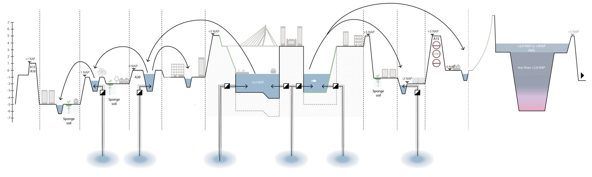
Section of the city of Rotterdam – Proposal, situation during periods of drought
To retain water from previous “wetter” years and seasons, Rotterdam needs about 3,000 urban water buffers (as shown on the map below within the dotted yellow area), which all can store 20,000 m3 within the least salt intruded area. And the interesting thing is that because we partly disconnect the New Meuse, means that the salt intrusion will only mainly come from the south and a little bit from the west and that we can actually concentrate that the New Meuse is becoming the most central freshwater buffer that we have and has the least effect of salt intrusion.

Water balance Rotterdam Watercity 2100 - Rough calculation test
In dry periods also the region can help with supply of fresh water during long periods of drought. Potentially, the polder of Krimpenerwaard can become vital for the Rotterdam Water city, to supply in its freshwater demand by using it as a pre-treatment ecosystem service and if needed the effluent of the wastewater treatment can be transported there.
Currently the polder is peat land and prone to subsidence, because for agricultural reasons the water levels are maintained low by pumping out the water. When we start pumping out less in this area, the water levels can come up again. This will stimulate peat growth through peat-forming vegetation serving as pre-treatment of fresh water and subsequently stimulate carbon sequestration, since wetland soil appears to be the most effective (on land) in CO2 storage. With the 12,000 hectares that the polder has, it can yearly store 8 megatons of CO2. And in comparison, the city of Rotterdam now produces only 3 megatons of CO2.

The polder of Krimp-enerwaard is vital for Rotterdam Watercity
The following scheme shows then how the complete closed freshwater cycle of Rotterdam could look like, with the existing base layers on the left, the modalities to collect and recirculate in the middle, and the long-term storage, cleaning, and supply on the right.

Schematic overview of a closed freshwater cycle in Rotterdam