River dike
Rotterdam, The Netherlands
Location | Rotterdam, The Netherlands
Year | 2009 - 2012
Client | Rotterdam Climate Proof, City of Rotterdam, Ministry of spatial planning, Waterboards of Schieland & Krimpenerwaard, Hollandse Delta and Delfland, Ministry of Infrastructure & Environment (I&M)
Collaboration | Deltares, Arcadis, Royal Haskoning, City planning departments of Rotterdam and Schiedam
Status | Explorative study on typology and process innovation, book and Research and design on dike reinforcement measurements for 'dikering 14' in Rotterdam. Input for IABR Rotterdam 2012 and the national Delta Programme
We propose a series of innovative dike designs that both strengthen their safety and improve their quality as urban spaces. After analyzing the existing Rotterdam dikes, DE URBANISTEN defined four strategies for four different locations in the city of Rotterdam. These four strategies increase in level of complexity and each one is illustrated on its most suitable location in Rotterdam. Therefore they are designs that serve as material for discussion between different professionals, in order to understand the full potential that an integrated approach can bring to all parties involved.
Water is a quality but also a threat for the city of Rotterdam. The combination of sea level rising and increasing amounts of water brought by the river from upstream, form a serious future challenge for the Rotterdam river dikes. How can we turn this threat into an opportunity to create new relationships between the city and its main water, the river Maas?
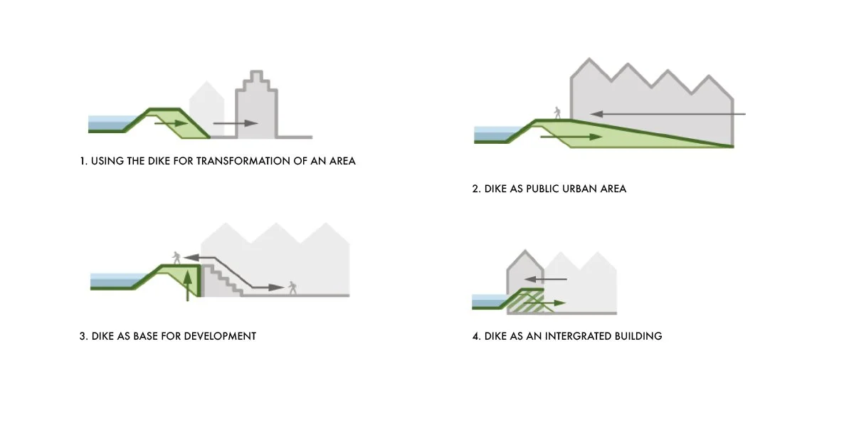
Four strategies, increasing in complexity
We propose a series of innovative dike designs that both strengthen their safety and improve their quality as urban spaces. After analyzing the existing Rotterdam dikes, four strategies were defined for four different locations in the city of Rotterdam: the dike as instrument to transform areas; the dike as public urban domain; the dike as a basis for urban development; the dike integrated into a building. These four strategies increase in level of complexity and each one is illustrated on its most suitable location in Rotterdam. Therefore they are designs that serve as material for discussion between different professionals, in order to understand the full potential that an integrated approach can bring to all parties involved. This project is conceived in extensive series of workshops that we led and elaborated in exemplary design proposals.
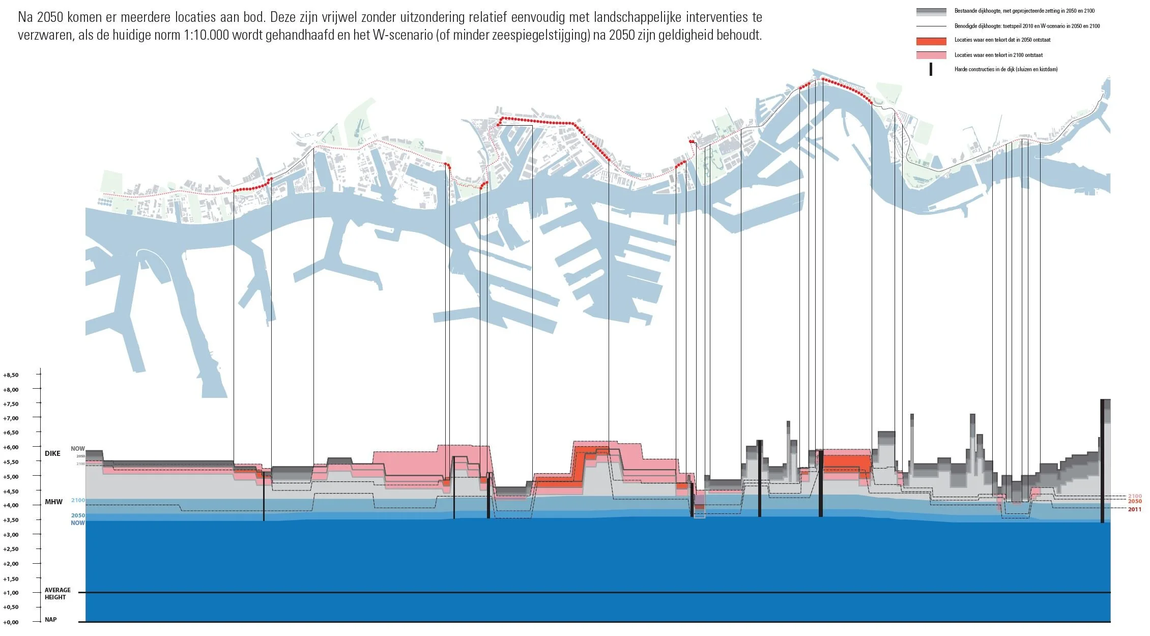
In 2011 the national government was researching strategies to make the Netherlands as ‘watersafe’ in the future as it currently is, taking into account the effects of climate change. DE URBANISTEN studied the northern Rotterdam river dike once more, but this time we took a real close look on the full length and we used less dramatic climate predictions. What reinforcement measurements are needed and how are they related to future urban developments?
Our analysis mapped current spatial qualities, difficult locations, plans and their status on one hand. On the other hand we meticulously scanned the current conditions of the dike in relation to requested heights and profiles in 2010-2050-2100.


From this scan we detected a majority of dike stretch that is high enough, much wider than needed and relatively easy to adjust. We also detected a few places where adjustments are needed. Three of these locations (the largest ones) can be effectively combined with actual planning processes. Here the main strategic advice is to bring dike adjustments to the agenda earlier than strictly necessary from a safety point of view. When combining these into a single spatial planning procedure a substantial extra value can be obtained.
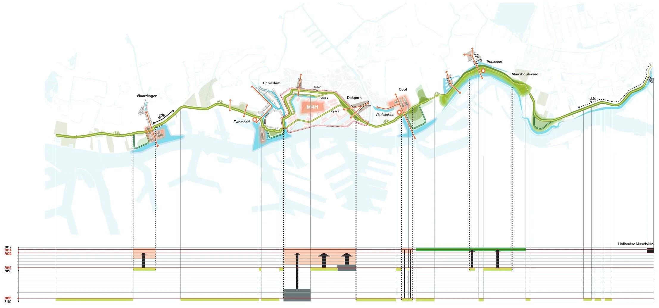
To prove this we worked out a case study on Merwe/Vierhavens area with three different positions of a reinforced dike. This position is closely related to the development potential of the site and related to social-economic conditions. Therefore we examined three possible economic realities and connected them each to a development strategy and dike position. These scenarios have been explored more in depth in our Clean Tech Delta project.
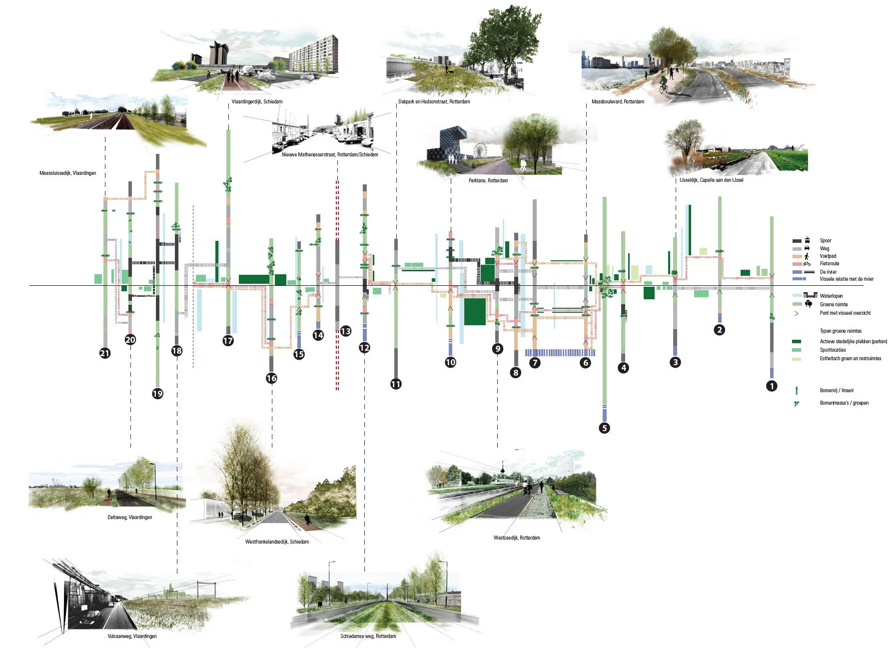
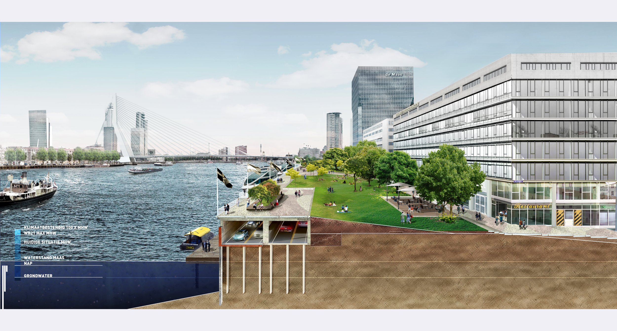
Spatially the river dike can be strengthened as a green continuous recreational structure. Since it is over dimensioned on so many places this can be done by redesigning the profile in a more approachable and friendly manner and by strategically placing trees. When extra height is needed this can be done by placing a continuous bike path as much as possible on top of the dike. This further diversifies the dike profile into a structure that allows interesting different views for bikes, pedestrians and cars to both the river and the city.