Waterplan
Antwerp, Belgium
Location | Antwerp, Belgium
Year | 2018-2019
Client | City of Antwerp
Status | Municipal strategy document, officially approved
Collaboration | Witteveen+Bos Belgium, Common Ground
Workshops | Municipal departments, Aquafin, Water-link, Province of Antwerp, AG Vespa
Downloads | Waterplan Summary (Dutch)
The Waterplan gives an inspiring vision of how the city has to approach future projects to get ready for a climate with larger extremes. This also makes an attractive living environment made for all inhabitants of Antwerp that offers flexibility to be able to continue to adapt to a changing future.
Our climate is changing worldwide. The consequences of this are no longer abstract, but now noticeable in cities worldwide several times a year. This will only increase in frequency, rain will fall more often in short periods with a very high intensity. We also have to deal with longer consecutive periods in which there is no rain at all, which can cause drought problems.

The way in which most of our cities are designed causes that they are not resistant to these types of extremes. The consequences are floods, subsidence of the soil, drinking water shortages and heat stress. Due to climate change urban regions are facing serious social, ecological and economic challenges. At the same time, these challenges offer the opportunity to start shaping a sustainable future for our cities.
The Waterplan gives an inspiring vision of how the city has to approach future projects to get ready for a climate with larger extremes. This also makes an attractive living environment made for all inhabitants of Antwerp that offers flexibility to be able to continue to adapt to a changing future.

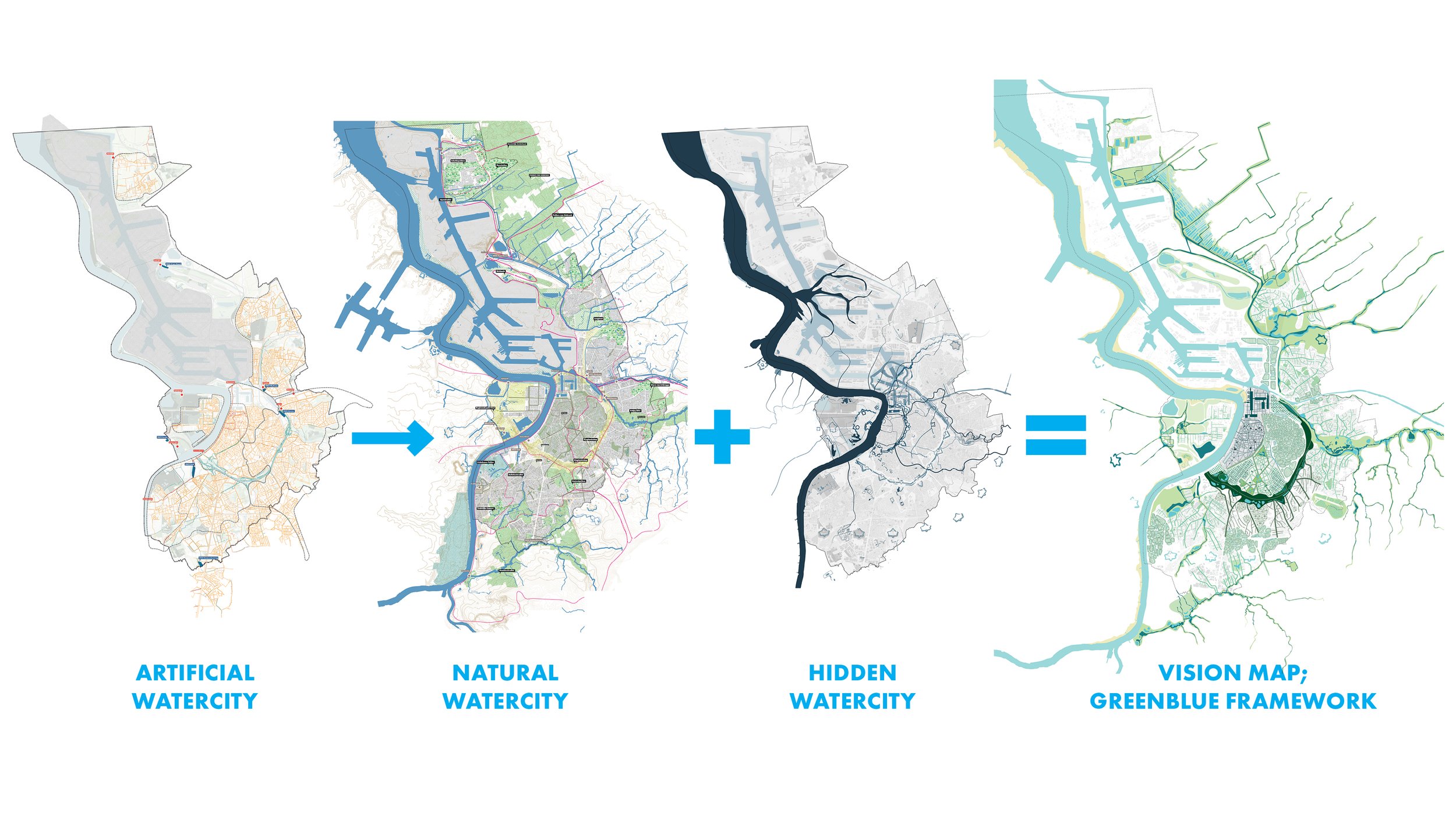

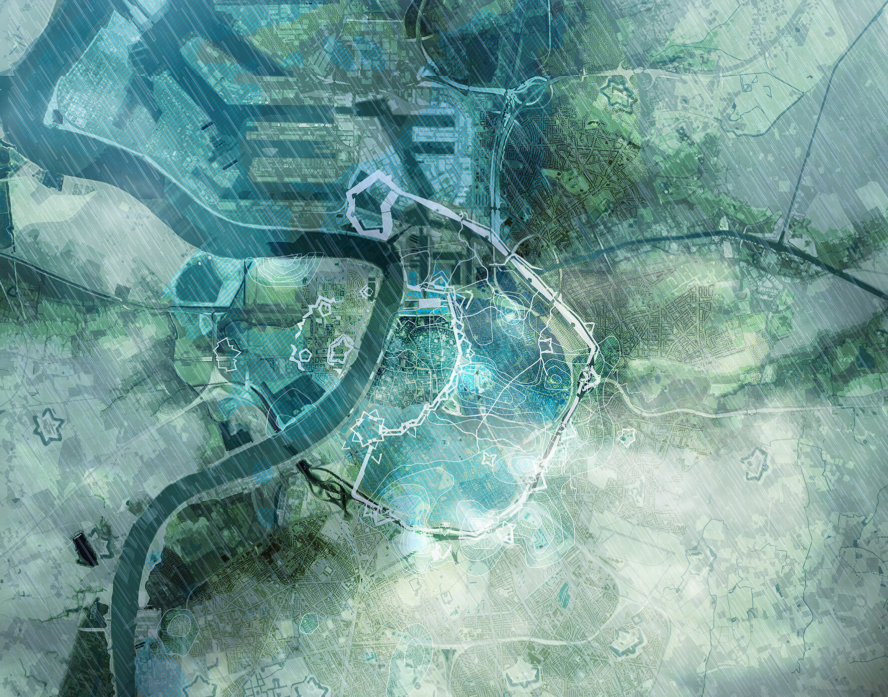
In the Waterplan three ‘watercities’ are described; The artificial watercity (this is the current sewage system of the city), the hidden watercity (these are the historical, often dissapeared traces of water in the city) and the natural watercity (these are the natural waterchanels and green areas in and around the city). Main ambition of the waterplan is to move the focus from the artificial watercity towards the natural watercity and bring back historical water traces where possible.


The three watercities together form the base for the layers of the Waterplan vision map. In this vision we created a framework that consists out of five main waterstructures. These structures are the result of the historical natural and urban growth of the city. For each of the five main waterstructures a rainwater cascade has been developed which helps achieving the Waterplan ambitions. We provided the rainwater cascades with applicable watersensitive measures.


To test the theory of the Waterplan we worked out three examplary cases. For one entire rainwater cascade we made a proposal on what measures have to be taken to delay the rainwater as much as possible within the cascade itself. For the residential area ‘Stuivenberg’ in the dense city centre we studied on how the water task can be solved as local as possible by rigourosely greening streets and organizing space in squares to temporarily hold rainwater when neccessary. Also we looked closer at the potential of the historical structure of the ‘Ruien’. This waterstructure could potentially be of more value in the city centre.


