Rotterdam Waterstad 2100
Rotterdam Region, The Netherlands
Location | The Rhine-Meuse estuary (Rijn-Maasmonding), The Netherlands
Year | 2022 - 2023
Clients | EO Wijers association, Municipality of Rotterdam, Deltaprogramma Rijnmond-Drechtsteden, Port of Rotterdam, Provincie Zuid-Holland
Status | Finalist EO Wijers (Honorable mention)
Collaboration | Deltares
Links | Complete vision (in Dutch), website EO Wijers
Rotterdam Waterstad 2100 is a hopeful and inspiring vision for the Rhine-Meuse estuary a hundred years from now. In our vision, we start with an extreme climate scenario in which we protect urban areas against rising sea levels, and the region will provide for its own freshwater needs. The vision illustrates how existing and new "green-blue networks" create a healthy and pleasant living environment. As such, the perspective also addresses the other challenges faced by the region, such as the protection from floods, dealing with droughts, and the enormous housing challenge.

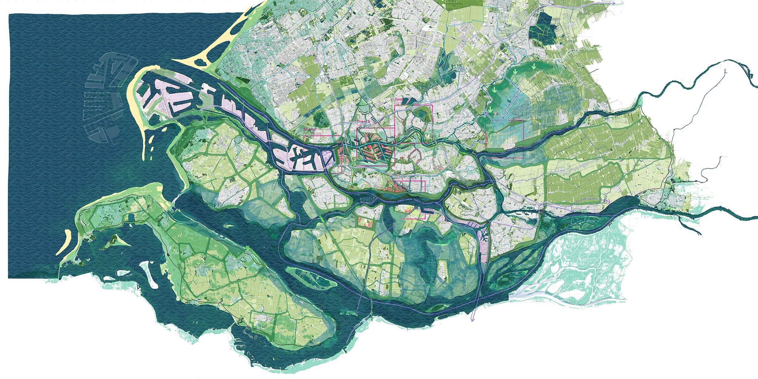
Timeline that shows the challenges of the region (partly based on a scheme shown in a presentation by Tim van Hattum)
We are here to stay!
Our vision starts from the premise that we are not going to give up on Rotterdam and the rest of the Randstad, even in the most extreme climate scenarios that are predicted today. The main intervention of this holistic vision is the implementation of a new dike that secures Rotterdam and the Randstad area against the extreme scenario of a three-meter sea level rise. Outside of this dike, particularly around the islands of South Holland, a dynamic and natural tidal landscape emerges. Residential centers on these islands are safely located behind smaller dike-rings, and the Rotterdam harbor is gradually heightened up to become future-proof.

Future perspective fot the Rhine-Meuse estuary at three scale levels
Water safety in extreme scenarios
Water safety plays a role both inside and outside the primary dikes. In our vision, the city of Rotterdam and the Randstad area are secured behind an improved “delta dike”. New sea locks on the east and west sides of Rotterdam keep the rising and salty seawater out and transforming a substantial part of the river into a fresh water buffer. Protecting the Drechtsteden follows a similar strategy: a dike ring with controlled inner water. The islands of Zuid Holland adopt a strategy in which the expansion of residential areas at a safe elevation, that can later grow into small ring dikes. This creates space for (new) tidal nature and wet forms of agriculture.

Interventions for a nature and climate sensitive Rhine-Meuse estuary in 2100
Holistic future perspective for the Rhine-Meuse estuary in the year 2100

Sponge Cities with circular freshwater-systems
The concept of a sponge city is necessary to ensure the availability of freshwater for the Rhine-Meuse estuary. This means capturing and retaining as much rainwater as possible, which can then be utilized during periods of drought and water shortages. Excess or rainwater can be redistributed through a (partially already existing) water system consisting of streams, canals, and pumps.


By partially “closing off” the Maas River from the sea, it will become possible to combine different water systems into one freshwater system, which can also serve as a buffer for rainwater. The Krimpenerwaard becomes a large purification marshland. Opening and connecting water structures more and more, in combination with improved water quality, this water network also will create new recreational possibilities.

Impression of how life on, and along the Meuse (Binnenmaas) could look like in 2100
Plenty of room for new nature
Rotterdam Watercity 2100 shows the potential of a large, 40km long riverside park that will connect the Krimpenerwaard with Midden Delfland all the way through the city center of Rotterdam. This park spans the entire length of the Binnenmaas and offers opportunities for new nature and recreational purposes. The Krimpenerwaard and Midden-Delfland, which are set to be made wetter, serve as regional parks. The Haringvlietdam will be opened, creating an extensive tidal park that extends all the way from the Haringvliet to the Biesbosch National Park.

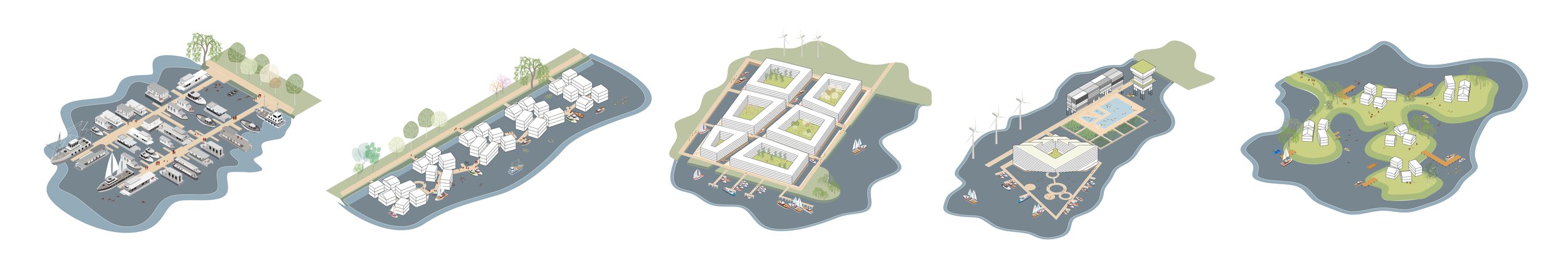
New Residential Areas
By partially relocating existing port areas and the main transport route over water towards the Oude Maas, the Binnenmaas becomes a place for "water and nature-based urban development." The controlled water level also offers opportunities for new residential developments and recreation on and in the water.
The Binnenmaas is a place for both nature and new types of housing, such as living in former harbor basins and floating houses. There are also opportunities for new residential areas on and behind the new delta dike. The locations on and near the dike become the new waterfront of the cities. In the tidal landscape outside the delta dike, housing development is part of the water safety strategy. By developing housing at an elevated level (on terps) on the outskirts of the existing villages, they eventually form a water barrier when these higher grounds are connected with a new robust dike.

Transformation of a tidal park into a riverside park along a controlled inner water (de Binnenmaas)
