
Over de ring
Antwerp
Location | Antwerp / Zwijndrecht, Belgium
Year | 2017 - ongoing
Client | Flemish government, Intendant office
Collaboration | OMGEVING, BAM (Lantis)
Status | Concept design, Masterplan, detailed design, construction starts in 2019
Overview selected projects can be found here
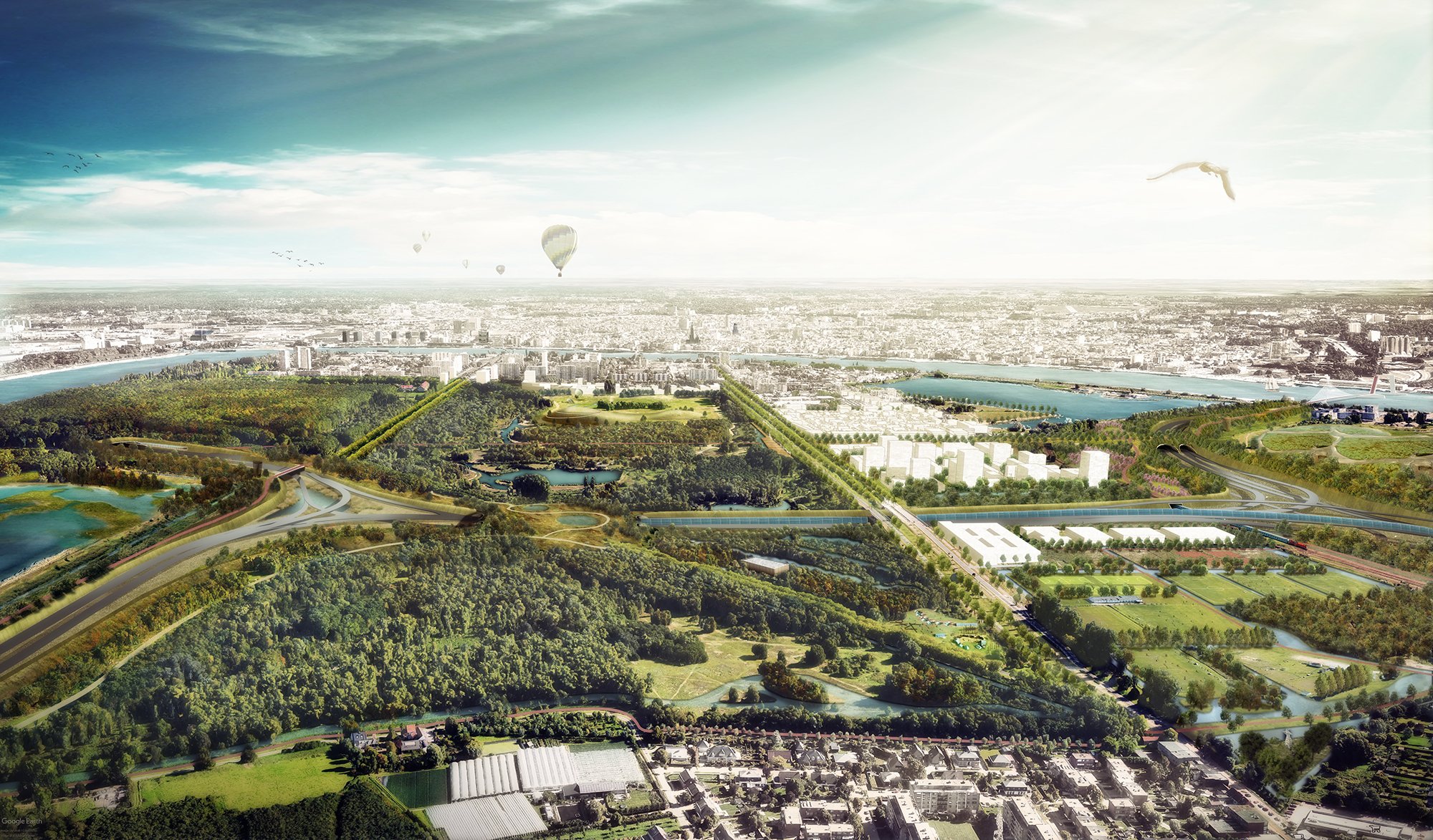
DE URBANISTEN together with OMGEVING made a proposal for a landscape park of almost 700 hectares on the Left Bank of the city. The basis of this landscape park is formed by various green areas ranging from a tidal area to a planted deciduous forest, from protected bird ponds to recreational lakes, from wet willow forests to reclaimed sand plains with meandering ponds, bushes and an event field.

Masterplan of the regional park
The task concerns the integration (capping) of the Antwerp Ring around the new connection between North and West that will close the Antwerp Ring (new tunnel under the Scheldt river). In the West segment, which includes the entire Left Bank (Linkeroever) and a significant part of the neighbouring municipality of Zwijndrecht. The task consists in particular of integrating detailed engineering work. This limited task has been reviewed and developed by team West (De Urbanisten together with OMGEVING) in a broader context.


The berm-landscape around the highway reduces noise and captures emissions in a sustainable way

Overview of the regional landscape park


Team West has scaled up the assignment into a proposal for a landscape park of almost 700 hectares on the Left Bank of the city. The basis of this landscape park is formed by various green areas ranging from a tidal area to a planted deciduous forest, from protected bird ponds to recreational lakes, from wet willow forests to reclaimed sand plains with meandering ponds, bushes and an event field. All this situated on a diked flood plain of the Scheldt river. The remaining characteristic is a multitude of open-water relations and the vaguely recognizable edge of the higher grounds on which the municipality of Zwijndrecht is situated.

For the integration of the highway we proposed to create generous green noise barriers that connect to existing green areas, which we raise up until eight meters above the highway and provide them with rich planting. The park will be pulled over the highway at strategic locations, where the most important ecological and park relations can be made. Also we opt to pass water generously under the highway, marking the western edge of the park and the transition to the higher grounds on which Zwijndrecht is situated. Watercourses are being widened and extended, which will give the landscape park an important function in the climate adaptation for Linkeroever and Zwijndrecht. At the newly created park edges, we situate new development locations for urban densification at four locations. Segment West for a long time was a forgotten part of the Ring. With the regional landscape park, we want to positively map the Left Bank by designing this area for the entire Antwerp and Zwijndrecht region and making it accessible.
The accessibility on foot or by bike both from and towards the Left Bank can be considerably improved in many ways. The city of Antwerp has the objective to accomplish a modal split of 50/50. The current bicycle network has several missing links both on the Left Bank as in Zwijndrecht. Many of the bicycle paths are also not considered to be safe or comfortable. Extending and optimizing the bicycle network into a clear spatial and performative structure is one of the main ambitions of team West. A better and more comfortable connection over de the Scheldt river is key in this. Therefore we propose Antwerp’s first bridge over the river (!) to be a dedicated bike and footbridge, strategically located at the south end of the city center, smoothly connecting to Zwijndrecht, the Left bank and its new regional park.
More info about the project is to be found on the website of ‘Over de Ring’
An overview of the selected projects is to be found here.
